Geology and Soils
The Geological History and Soils of the Sid Valley
Introduction
An understanding of the geology helps us to better appreciate the scenery and answer questions such as where do all the stones come from? Why do we have such steep-sided goyles?
The rocks of the valley were forged over a 250 Million-year time span during which we drifted slowly northwards to our present latitude of 50.6N. We’ve had our ups and downs with rocks formed on land and under the sea and have endured periods of global warming and cooling.
Triassic Period
251 – 200 Million Years
During this time, the Eurasian Plate on which the Sid Valley sits, formed part of the supercontinent of Pangea. We were 15°– 20°N of the Equator in a desert environment akin to the Sahara today. Most of our Triassic rocks and the soils formed from them are red. Desert rocks are often red because each grain is coated with an iron oxide akin to a layer of rust.
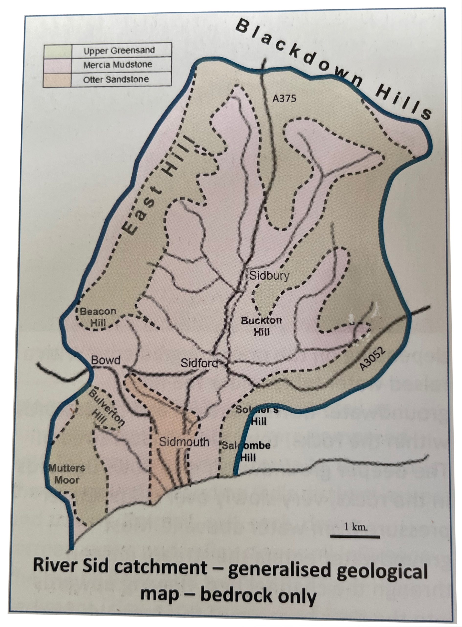
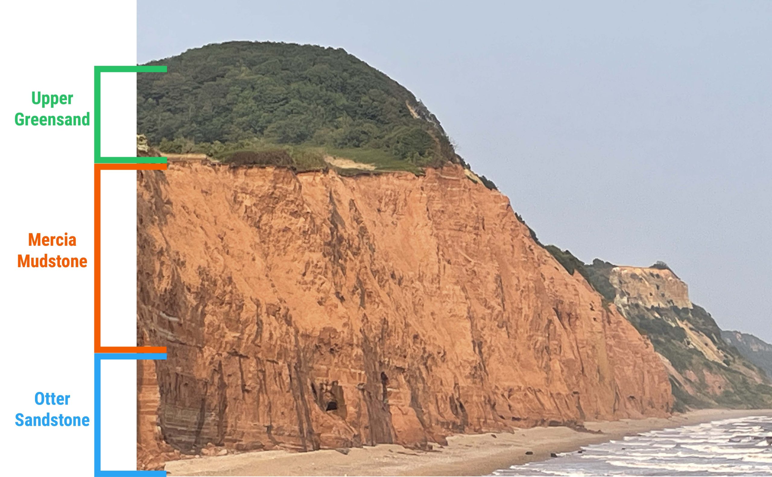
Otter Sandstone
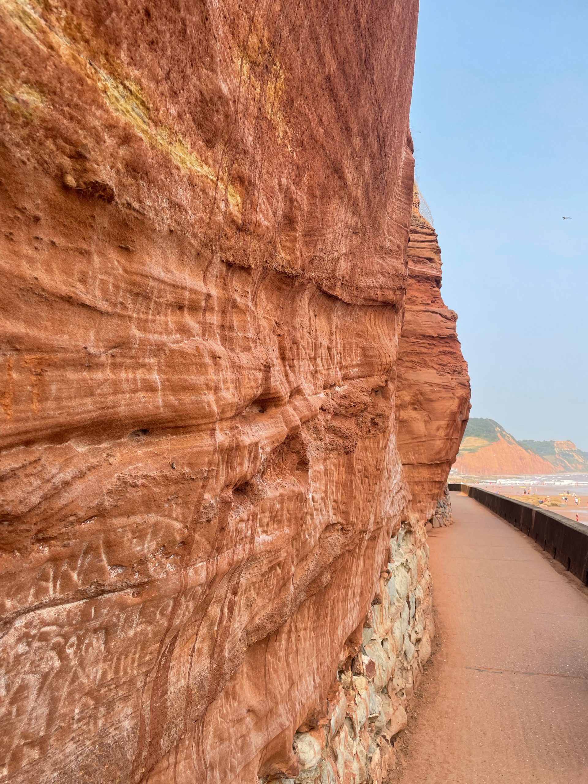
[200m thick approx.] This is the oldest Triassic rock seen in the valley and is found only in Sidmouth. Sand was blown or transported by water from mountains to the west on to this vast hot, dry lowland area, which extended from the Midlands to Northern France and across southern England. In contrast to today we were hundreds of kilometers from the sea. Dartmoor granite is part of the eroded mountain core. Over millions of years, sand layers accumulated and were buried and compressed into rock.
The Otter Sandstone is the backdrop to Millenium Walkway and forms the steep cliff to the East of the River Sid, close to its mouth. This rock stores water between the sand grains and forms part of the aquifer which supplies our drinking water. It is abstracted from boreholes in the Otter Valley.
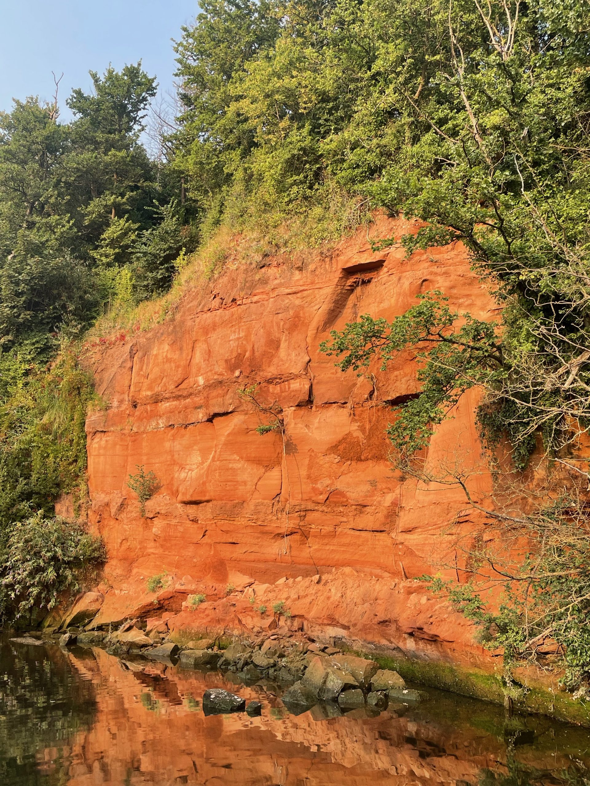
Mercia Mudstone
[450m thick approx.] This is the predominant rock in the Sid valley. It forms the crumbly cliffs seen at Jacobs Ladder Beach to the west and is seen along the coast to the east. The mountains to the west were much lower than in Otter Sandstone times and the sediment deposited finer grained, more muddy than sandy. Water in desert lakes readily evaporated in the intense heat leaving salt deposits behind. The most important salts were calcium carbonate [source of agricultural lime] calcium sulphate [gypsum] and sodium chloride [salt]. The 1906 Ordinance Survey Map reveals that the valley was once littered with marl pits where lime was found, dug out and spread on fields to improve the soil. This once valuable labour-intensive resource gave way to imports of more concentrated sources of lime.
Jurassic Period
200 - 145 Million Years
There’s no record of Jurassic rocks in the valley. They may have been deposited and then eroded.
Cretaceous Period
145 – 66 Milion Years
During this this time this area was submerged under the sea. By the late Cretaceous the earth’s climate was very warm indeed, the earth average temp thought to be 10° hotter than today and with no ice locked up at the poles, sea levels were up to 70m higher than today. There were huge blooms of marine algae in the oceans and their calcium shells were compressed into chalk rock. We were 40°N of the equator still drifting towards our current latitude of 50.6°N.
Upper Greensand
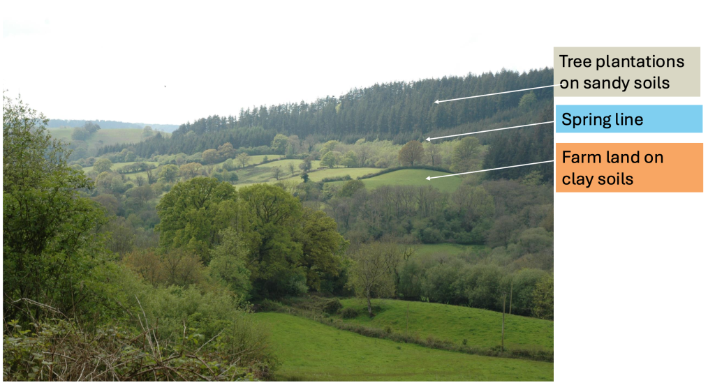
[50m thick approx.] This is the marine sand which now rests on the Mercia Mudstone in the valley. It was deposited in shallow water close to shore. It is called ‘green’ because it contains a green mineral called glauconite, which quickly breaks down when exposed to the air. As with the Otter Sandstone, Greensand holds water. It is found in a 50m layer around the top of the valley. Today, it’s usually covered by forestry plantations or other woodland. A spring line marks the boundary between the greensand and the mudstone because the water cannot move through the mudstone so readily or rapidly it is diverted sideways and emerges as springs many of which flow year round, water logging surrounding land.
Chalk
A huge thickness of chalk, up to 1000m, may have been deposited over East Devon but has long since eroded.
Tertiary Period
66 – 2.6 Million Years
Earth movements, begun in earlier times, continued. We were once again on dry land and rock layers gently tilted 5 degrees towards the East.
Rocks cracked to accommodate the earth movements. In the Sid Valley it is difficult to determine the extent of faulting but in Sidmouth a large slice of Otter sandstone was pushed up and is sandwiched between the younger Mercia Mudstone, which forms the crumbly cliffs on both sides of the town.
One of the obviously faulted areas is at Jacobs Ladder. Areas weakened by shattered rocks are ideal sites for valleys to form. All the river valleys in East Devon are sited on North South trending fault zones. These earth movements were in part the ripple effect from plate moments including the African plate pushing northwards against the Eurasian Plate, which led to the formation of the Alps.
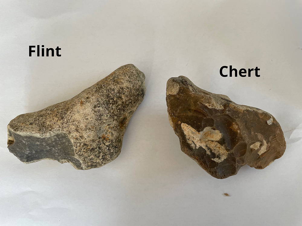
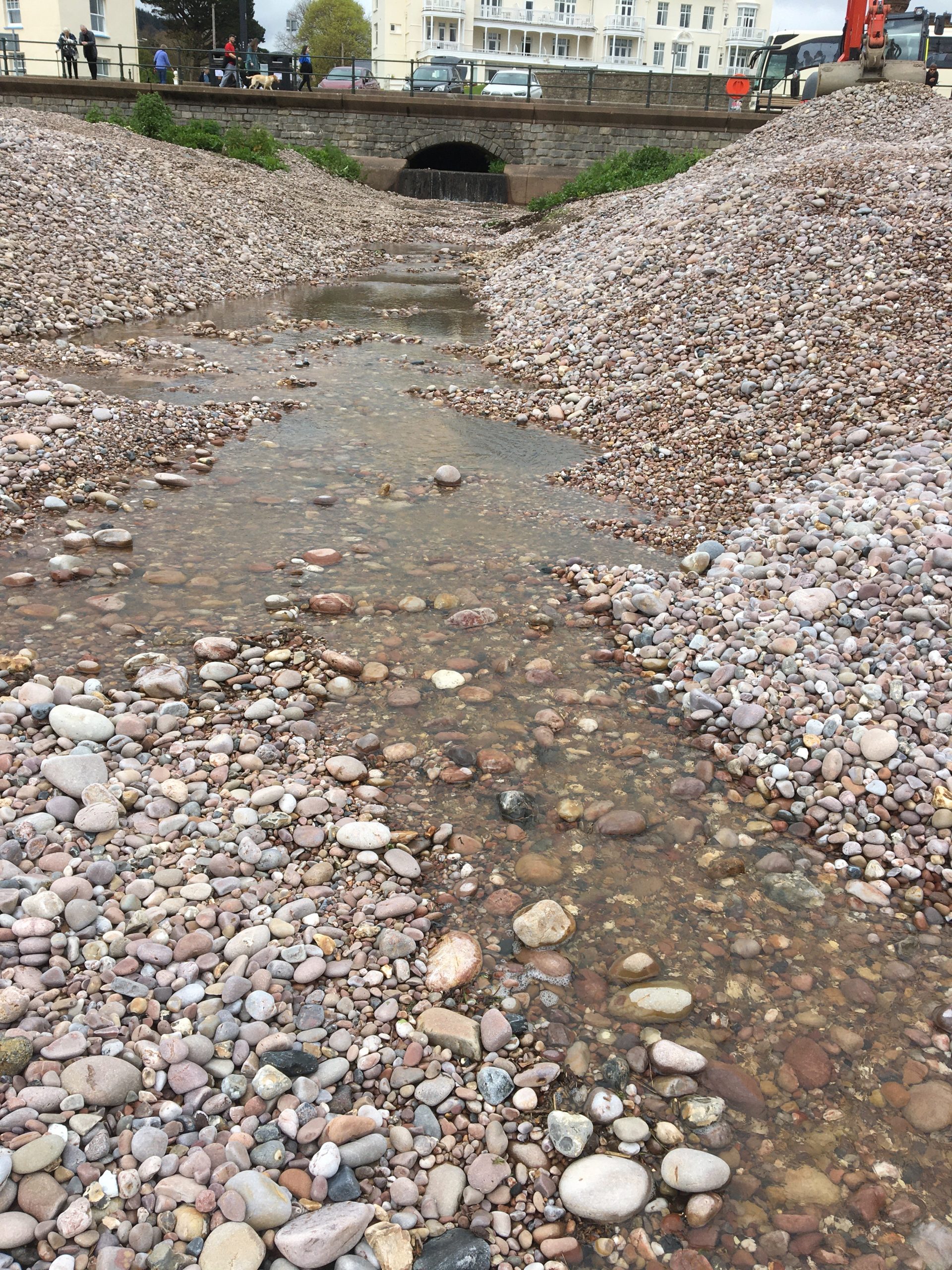
The climate was warm and erosion intense. The chalk rocks are gone leaving the tell tale residue of flints and clay. The greensand was subject to partial erosion with chert left as a legacy. Chert and flint are very similar both consist of microscopic crystals of silica. They each take some characteristics of their mother rock. Chert is usually a brown sandy colour and flint often has a chalky white coating. The silica in both cases comes from the remains of the shells of tiny sea creatures called diatoms and radiolarians and the internal silica needles of sponges. During rock formation the silica dissolved in water and often accumulated in lumpy stones called nodules which are highly resistant to erosion. Once used for tools and weapons, they litter the fields and collect as stony banks in our watercourses and are visible in the many stone walls in the valley.
Quaternary Period
2.6 Million Years - Present
A major feature of the late Quaternary was a series of ice ages the most southerly extent of the ice was N Devon but Dartmoor may have had an icecap and valley glaciers. We would have been in a region with bitterly cold winters and brief warm summers. The resulting cycles of freeze and thaw breaks rocks apart just as it cracks pipes and resulted in the formation of sandy or muddy sludge mixed with stones of flint and chert up to 15m thick. These superficial deposits coated the flat land at the top of the valley and slumped down the steep valley sides. The movement of large quantities of summer melt water was a powerful erosive force enabling the Sid and its tributaries to cut deep goyles through easily eroded sand and mudstone rocks in the upper reaches of the valley.
During intense periods of cold, much water was locked up as ice and sea levels dropped to 100m lower than today. The River Sid would have been longer and the English Channel was a river valley. As sea levels rose the Sid Valley began to look more like it does today and a flat wide estuary area was created which extended across the valley but the river has since been confined and channelled to the extreme east and Sidmouth built on the estuarine flat land. Our once lowest tributary stream, Bickwell Brook was cut off by the rising sea and now forms a separate small valley on the West side of Sidmouth. It runs through Glen Goyle and on to Town Beach.
Our turbulent and varied geological history explains the origin of our scenic valley, which presents such huge challenges for soil management.
Soils
Introduction
Natural soils are formed as a result of the interaction between climate, geology and biological processes. Local topography, the vegetation and soil biota continually modify a soil’s characteristics and human influences such as forest clearance and agriculture have a significant effect.
Soils are not merely a growing medium, they have active ecosystems supporting a wide variety of micro and macro-organisms that breakdown organic matter and in their own life processes excrete nutrients important for plant growth. Soil fungi called mycorrhizae have mutually beneficial partnerships with plants. They form close associations with plant roots and provide a range of nutrients and enhance access to water, in turn, the plants provide sugars to the fungi.
Healthy soils rich in organic matter have many benefits. They are important in the recycling of nutrients and some carbon but a proportion is converted by soil organisms into carbon compounds which remain in the soil if it isn’t ploughed. Organic matter in the soil acts like a sponge in soaking up water and then releasing it slowly, this filters the water and contributes to flood regulation. At the other extreme, soils with little organic matter and compacted by heavy machinery are easily eroded as water, laden with soil, runs off rapidly on to roads and into local water courses.
Major Sid Valley Soils
East Devon Plateau at the top of the valley, is covered with acidic poorly draining clay-based soils with plentiful stones of chert and flint.
Greensand slopes have well drained permeable sandy loam which can support rough grazing and woodland. Once fields of sheep could be seen in areas now given over to forestry.
Mudstone [below the Greensand] is found on valley slopes and bottoms. The soil is a clay loam characterized by seasonal waterlogging due to the limited permeability of the clay subsoil. The subsoil can have a gleyed (mottled) appearance due to the movement of iron oxides. Iron is leached from the red soil in waterlogged conditions when anaerobic bacteria change the rusty red ferric iron oxide to grey soluble ferric iron oxide which either accumulates in the subsoil or is removed from the soil dissolved in water. Soils subject to this process are called stagnogleys and require careful management to maintain their fertility.
Loose material from the East Devon Plateau and Greensand scarp moves into the valley, contributing a mix of stones, clay and sandy material to the mudstone soils. The land is largely pastoral with some arable crops including cereals, rape and maize.
River valleys the lower valley bottoms contain sands silts and clays known as river alluvium forming fertile floodplain soils up to 2m thick.
Newsletter
Subscribe to the newsletter to stay up to dates with the latest news along the River Sid,
including conservation work, volunteering opportunities, and useful information.